Byway Maps
Navigate 131 Miles of Scenic Colorado History
Gold Belt Tour Maps

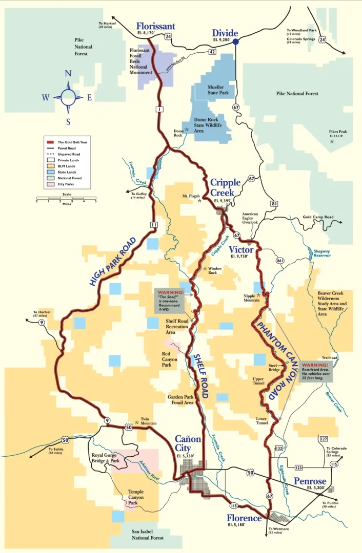
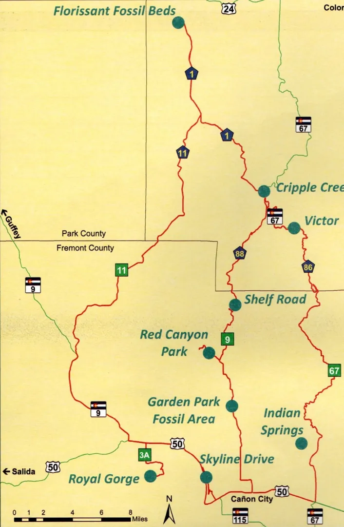
The Gold Belt Tour Scenic and Historic Byway offers one of Colorado's most diverse and historically significant driving experiences. This 131-mile route connects five distinct communities—Florissant, Cripple Creek, Victor, Cañon City, and Florence—through terrain that ranges from high alpine meadows to dramatic rocky canyons carved over millions of years.
Whether you're seeking stunning photography opportunities, outdoor adventure, or a journey through Colorado's gold rush heritage, these detailed maps will help you plan your perfect Gold Belt Tour experience. Each of the four roads that comprise the byway offers unique characteristics, challenges, and rewards for travelers willing to explore beyond Colorado's main highways.
Please note that Shelf Road and Phantom Canyon Road include unpaved sections with vehicle restrictions. Shelf Road narrows to one lane in places and 4-wheel drive is recommended. Phantom Canyon Road restricts vehicles over 25 feet in length. Plan accordingly and check current road conditions before your trip.
Four Distinct Roads, One Unforgettable Journey
The Gold Belt Tour consists of four interconnected roads, each with its own personality and attractions. We recommend using our detailed maps to understand road conditions, elevation changes, and seasonal accessibility before you depart.
High Park Road forms the northern section, connecting Florissant to Cripple Creek through rolling mountain parklands and meadows. The route showcases the transition from Pikes Peak's eastern slopes to the Cripple Creek mining district, passing through forests of ponderosa pine and aspen. This is the most accessible year-round route, with paved sections and gentle elevation changes that make it suitable for all vehicle types.
Shelf Road stands as one of Colorado's most dramatic backcountry drives, descending from Cripple Creek to Cañon City along a historic wagon route carved into limestone cliffs. This unpaved road features sheer drop-offs, narrow passages, and world-renowned rock climbing areas. The 12-mile route requires careful navigation and is best suited for high-clearance vehicles during dry conditions.
Travelers are rewarded with spectacular canyon views and access to unique geological formations.
Phantom Canyon Road follows the abandoned bed of the Florence & Cripple Creek Railroad, winding 35 miles through a narrow gorge between Victor and Florence. This backcountry route features 17 creek crossings, overhanging rock walls, and remnants of Colorado's gold rush era including old railroad grades and mining structures. The unpaved road requires high-clearance vehicles and typically closes during winter months and spring runoff.
Teller County Road 1 serves as a scenic connector linking Cripple Creek and Victor, traveling through the heart of what was once the world's greatest gold camp. The paved route passes active and historic mining operations, offering visitors a close-up view of Colorado's continuing mining heritage. Though short, this historically significant road provides access to numerous museums, mine tours, and interpretive sites that tell the story of the region's billion-dollar gold boom.
Essential Trip Planning Information
Before you embark on your Gold Belt Tour adventure, understanding the unique characteristics of each route will help ensure a safe and enjoyable experience. Our detailed maps include critical information about road conditions, seasonal closures, and recommended vehicle types for each section.
Road conditions vary significantly throughout the year. High Park Road and Teller County Road 1 remain accessible in most weather conditions, while Shelf Road and Phantom Canyon Road are typically closed from late fall through early spring. Summer thunderstorms can create hazardous conditions on unpaved sections, particularly on Shelf Road's exposed cliffs and during Phantom Canyon Road's creek crossings.
We strongly recommend checking current conditions before attempting the backcountry routes.
Vehicle requirements differ by route. While any passenger vehicle can safely navigate High Park Road and Teller County Road 1, both Shelf Road and Phantom Canyon Road require high-clearance vehicles. RVs, trailers, and low-clearance vehicles should not attempt these backcountry sections. The unpaved roads feature steep grades, narrow passages, and water crossings that demand careful attention and appropriate equipment.
Allow plenty of time for your journey. While the entire 131-mile route could theoretically be driven in a few hours, we recommend setting aside a full day or splitting your trip across multiple days. The byway's numerous attractions, scenic overlooks, and historic sites deserve time to explore.
Most travelers find that spending six to eight hours allows for a comfortable pace with stops at key attractions, though dedicated history enthusiasts and photographers often prefer two or three days to fully experience everything the Gold Belt Tour offers.